SITTING BEAR MOUNTAIN
DEVIL'S CLIFF
AT LINVILLE GORGE
 |
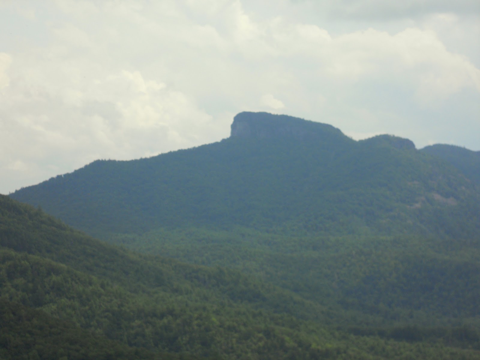
| LOOKING AT DEVIL'S CLIFF FROM SITTING BEAR MOUNTAIN |
 |
| FBWG on Devil's Cliff |
Sitting Bear Mountain has been a destination on our bucket list....but when I looked at the hike I was drawn to Devil's Cliff as well....folks saying that from the Cliff you can see the entire length of Linville Gorge....on paper a six mile hike....but on the ground....some of the steepest climbs of the summer! But the views were well worth the effort!
 |
| Smiling Sitting Bear Rock |


I had read the reviews on the hike and had some idea of how steep the trail was...but did not tell my hiking companion....she really likes surprises!


The trail to Sitting Bear Summit is a little over a mile....the elevation at the trailhead is 3300 feet.....the summit is nearly 4100 feet....but the steep part of the trail might be 3/4 miles long and at several points you are scrambling with hands and feet on the ground! Once you near the summit, there are several side trails leading to cliffs from which there are many great views of the Gorge.

A cold front had just passed over the Gorge and the low hanging clouds were just lifting allowing us our first glimpse of our destination.....Devil's Cliff.

A low puffy cloud provided a nice crown to accent the summit of Hawksbill Mountain.


Table Rock Mountain was outlined by clouds as well. From this cliff you could look south and watch the clouds rise and reveal the Linville Gorge.


Further up the trail we encountered the signature feature of the Sitting Bear Mountain....there was a large rock, easily three stories in height...and from several angles it looks like a sitting bear!
The steepest part of the trail is the final ascent to the summit. It is virtually straight up! Fortunately for the FBWG some nice Boy Scouts had recently cut a narrow switchback trail, though longer, at least we could climb it on two feet standing up! At the summit, we had a scare....my hiking companion spied what she thought was a wolf standing in the trail to the summit overlook! And through the leaves covering the trail I made out the outline of a large animal that looked like a dog but truthfully made me pause. As we backed down an escape trail, one of those disgusting Linville Gorge trail runners appeared and soon the "wolf" followed her down the trail.....it was a really big dog!
 |
| Looking Southeast from Sitting Bear Mountain |
 |
| Looking south down Linville Gorge from Sitting Bear Mountain |
 |
| Looking Northeast from Sitting Bear Mountain |
From the summit, we had some of the best views of the day.
 |
| Looking east from Sitting Bear Mountain |

From the summit, we traveled north along the Jonas Ridge Trail. The relatively flat but rocky trail was a relief after climbing Sitting Bear Mountain.


In about 3/4 of a mile, we easily found the Devils Cliff trail intersecting from the left. Just as the folks at Linville Gorge Net said the Devils Cliff trail went left, the Midcliff trail went to the right at a "Y" intersection. The Devil's Cliff Trail gently sloped toward the Gorge and along the way, we had glimpses of the views we were soon to see from the Cliff.

Also along the trail we encountered some interesting and colorful mushrooms.


 |
| Table Rock from Devil's Cliff |
After about a mile and a half we arrived at the Devil's Cliff...which in truth is a series of cliffs on a ridge that extends into the Linville Gorge. The first thing we saw was the western wall of the Linville Gorge.


The view of Table Rock Mountain was one of the best I have seen. The Devil's Cliff South offered a great view of the Linville River as well.
 |
| Looking South from Devil's Cliff North |
Scrambling over the cliffs, we found that the views from the northern portion of Devil's Cliff were just as stunning.
 |
| Looking North toward the Linville Falls |

From Devil's Cliff North we could see various features of the Gorge... I think this is Babel Tower.


One feature of the Devil's Cliff looked to me like the head of a snake.

Leaving Devil's Cliff we elected to take the Red Trail across the ridge to connect with Midcliff trail which would take us back to the Jonas Ridge Trail.... another steep trail!
 |
| Interesting reflections in a pool created by a spring on the Red Trail |
 |
| Three large trees on the Red Trail |
The Red Trail was a difficult trail that obviously was not well traveled and but for my Garmin and the downloaded map from Linville Gorge Net, I would not have found the Midcliff Trail which was so overgrown at the intersection with the Red Trail that we would have otherwise missed the trail.
 |
| Old hardwood on the Red Trail |

The Midcliff Trail was enormously difficult. It was steep and long. The trail was overgrown in spots and was very wooded with no real distinguishable views. If you go to Devil's Cliff, take the Devil's Cliff trail back to JRT and avoid the the Midcliff Trail.
The hike back was uneventful other than managing the steep climb down from the summit of Sitting Bear. We were thankful that it did not rain or otherwise I am sure we would have slid rather than walked down the trail. This was the toughest six mile hike I have attempted due to the steepness of the Sitting Bear Trail and the Midcliff Trail.
 |
| " The Beauty of the Mountain is hidden for all those who try to discover it from the top, supposing that, one way or an other, one can reach this place directly. The Beauty of the Mountain reveals only to those who climbed it..." - Antoine de Saint-Exupery |
 |
| FGWG on Cliff at Sitting Bear Mountain |
The trail was very challenging but the views were worth the effort. FBWG ranks the views a 9....the trail access a 9.... the trail a 7 due to steepness and the overgrown and difficult nature of the Midcliff trail....overall ranking an 8....
The FBWG has been hiking for 10 consecutive weeks....I thank you for following my exploits....next weekend is a UNC football scrimmage (#62 is my kid) and I will take the week off.
The FBWG has been hiking for 10 consecutive weeks....I thank you for following my exploits....next weekend is a UNC football scrimmage (#62 is my kid) and I will take the week off.
Great pictures of the lovely gorge.
ReplyDeleteI've only been to Devil's Cliff once and I approached it from an entirely different angle (from Yellow Brick Road trail).
Did you have any trouble locating Devil's Cliff from the JRT? I'd like to go on this hike myself but I'm a little worried about losing my way.Also, did you use a GPS or simply a compass and map?
Again, really beautiful pictures!
no problem finding the Devils Cliff trail off JRT....it is marked with several rocks....I use a Garmin 450T downloaded with Linville Gorge Net maps.....go to the Linville Gorge Net and there is plenty of good info there.... FBWG
DeleteThanks for sharing, really loved the pictures and the trail information!
ReplyDelete~darkbyrd
Been to Sitting Bear one time and yes, it is a steep hike. Gonna try Devil's Cliff Trail and may go back up Sitting Bear. Good pics and info.
ReplyDeleteBeen to Sitting Bear one time and yes, it is a steep hike. Gonna try Devil's Cliff Trail and may go back up Sitting Bear. Good pics and info.
ReplyDeletethanks so much!! looking forward to doing this one soon!
ReplyDeletePaul