CROWDERS MOUNTAIN
Just south of Charlotte on I-85 looms two mountain peaks located in Crowders Mountain State Park. The Fat Bald White Guy and his hiking companion visited Kings Pinnacle last year.( http://fbwg-hiking.blogspot.com/2013/04/kings-pinnacle-at-mountain-state-park.html) We decided to hike Crowders Mountain on a 75 degree day on the first Saturday of Spring.
You may access both peaks from trails from the visitor's center. The trek to Kings Pinnacle is a moderately steep trail of 2 miles. The trek to Crowders Mountain is considerably longer. When we visited the park the first time we only hiked Kings Pinnacle saving Crowders Mountain for another day. Combining the hike with a trip to Kings Mountain National Military Park resulted in about 5 miles of hiking and a great day. (http://fbwg-hiking.blogspot.com/2014/03/kings-mountain-national-miltary-park.html)
To access Crowders Mountain it is best to use the Linwood Road access. Getting there is easy. Exit I-85 at the Crowders Mountain State Park exit. But follow the signs only to the first stoplight. Signs point to the right. Go straight and you will be on Archie Whiteside road and when it dead ends take a left and you will see the parking lot.
Be ready when you visit Crowders Mountain State Park to enjoy "sociable" hiking. The park is very popular and the trails are often very crowded. Today was no exception as we parked in one of the last spots left in the parking lot!
Crowders Mountain was once part of a large mountain range. It is an example of a geological feature known as a monadnock and though only 1634 feet in elevation, the peak is 800 feet above the surrounding countryside. You see this geological formation in several locations in North Carolina. Nearby Morrow Mountain in Stanly county and the Three Peaks of the Suara Mountain range in Stokes County (Pilot Mtn, Sauratown Mtn, Moore's Knob). I have profiled each of these peaks in earlier blog posts. These left over mountains are remnants of a mountain range thought to be more impressive than even the Rockies, seem to rise from the Piedmont foothills. While not reaching impressive elevations, all boast some spectacular cliffs. Crowders Mountain is no exception.
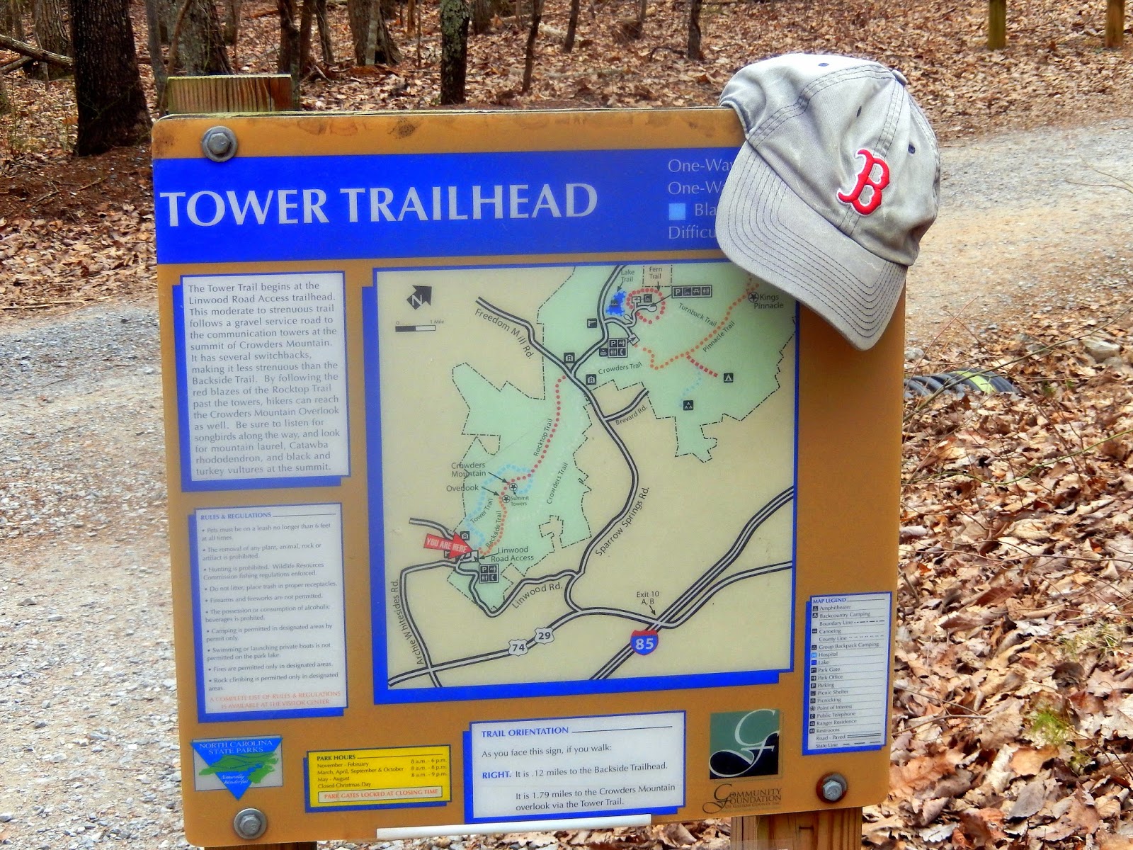 At the Linwood Road access, there are two trails to the summit. One is the Tower Trail which is a 1.8 mile trail along the gravel utility road to the southern part of the Crowders Mountain summit where transmission towers are located. The other is the Backside Trail which is a mile long trail to the northern part of the summit of Crowders Mountain. The Backside Trail is considerably more "sociable". Accordingly we took the Tower Trail.

 The trail is a long and winding gravel utility road which allows occasional views of the rocky Cliffside which is used by many rock climbers. At the 1.25 mile mark there is a rock bench on the side of the road. Take my advice and stop and rest here. The next 3/4 mile is a 450 foot ascent.
The road begins a number of switch backs from which you can get glimpses of the surrounding Gaston County countryside. As we arrived at the summit we had a nice view of the Kings Pinnacle summit in the distance.
The trail is a long and winding gravel utility road which allows occasional views of the rocky Cliffside which is used by many rock climbers. At the 1.25 mile mark there is a rock bench on the side of the road. Take my advice and stop and rest here. The next 3/4 mile is a 450 foot ascent.
The road begins a number of switch backs from which you can get glimpses of the surrounding Gaston County countryside. As we arrived at the summit we had a nice view of the Kings Pinnacle summit in the distance.
 We have seen almost monthly of reports of folks falling off Crowders Mountain and wondered what made this mountain so susceptible to such accidents. We soon got a look at some potential victims for this month's accident report.
 The Tower Trail ends at the transmission towers. You can pick up the red blazed Backside Trail at the rear of the towers. It is a narrow rocky trail but there is a really nice cliff to the left that provides a picturesque view of the Crowders Mountain Knob.

 While we were resting on the cliff and enjoying the view of the Crowders Mountain Knob, we were entertained by an aerial dance of some hawks which my hiking companion chronicled.

 Leaving the tower area we hiked a short distance to a number of rock cliffs which were very sociably occupied by all sorts of people, families and youth groups. We got to talk to three lovely young ladies from Beijing. One was a graduate at UNCG who was working on a project studying brain nutrients. I was surprised with the 156 views the Fat Bald White Guy has gotten from China that they did not know me?!....they were kind enough to allow me to photograph them....hopefully their friends in China will know that they got to hike with the Fat Bald White Guy.
The views were nice from the many different cliffs. The real problem was that there were far too many people vying for a spot on an open cliff that it ruined the back to nature feel of the mountain. I chose not to venture out to the northern cliffs but I captured a great pic of a couple on an isolated cliff.
Leaving the tower area we hiked a short distance to a number of rock cliffs which were very sociably occupied by all sorts of people, families and youth groups. We got to talk to three lovely young ladies from Beijing. One was a graduate at UNCG who was working on a project studying brain nutrients. I was surprised with the 156 views the Fat Bald White Guy has gotten from China that they did not know me?!....they were kind enough to allow me to photograph them....hopefully their friends in China will know that they got to hike with the Fat Bald White Guy.
The views were nice from the many different cliffs. The real problem was that there were far too many people vying for a spot on an open cliff that it ruined the back to nature feel of the mountain. I chose not to venture out to the northern cliffs but I captured a great pic of a couple on an isolated cliff.

 The way back to the parking lot is via Backside Trail which means going down steps and if you read this blog you know the FBWG hates steps on the trail....I only am thankful that we took the Tower Trail up so that I only had to go down the steps as I am sure would have vapor locked on this climb. From the base of the steps there is a nice view of the rock wall of the Crowders Mountain Knob, no doubt a favorite for climbers.

 The trail down was a wide well maintained trail. The Backside Trail is quite steep and would not be a crowd favorite on a hot summer day.
Crowders Mountain is a great day hike and wonderful place for a picnic. It is a rugged mountain and one which I plan to return to explore on a clearer, cooler day. The northern summit and the many cliffs are perfect locations for many nice pictures of the surrounding countryside including the skyline of the city of Charlotte. Access is an 8; the trails are an 8 was they are well maintained but also well used; scenery is a 7 for now but I am sure will be a 9 if I ever get out on the northern cliffs. Overall an grade 8 hike... a nice 3 mile loop to combine with our 1.5 mile hike at Kings Mountain National Battlefield Park .
The trail down was a wide well maintained trail. The Backside Trail is quite steep and would not be a crowd favorite on a hot summer day.
Crowders Mountain is a great day hike and wonderful place for a picnic. It is a rugged mountain and one which I plan to return to explore on a clearer, cooler day. The northern summit and the many cliffs are perfect locations for many nice pictures of the surrounding countryside including the skyline of the city of Charlotte. Access is an 8; the trails are an 8 was they are well maintained but also well used; scenery is a 7 for now but I am sure will be a 9 if I ever get out on the northern cliffs. Overall an grade 8 hike... a nice 3 mile loop to combine with our 1.5 mile hike at Kings Mountain National Battlefield Park .
KING'S MOUNTAIN NATIONAL MILTARY PARK
Located near the border of North Carolina.....just off I-85 is the King's Mountain National Military Park.....the site of the most significant battle in the entire Revolutionary War....the story would make a great movie....the Fat Bald White Guy and his hiking companion hiked the 1.5 mile Battlefield Trail and received a hands on history lesson....the Battle of Kings Mountain is one which I have read much about and walking the battlefield was a humbling experience. I first wrote about this battle in my Self Evident Truth blog, entitled "The Sword of the Lord and Gideon": http://privatekeep.blogspot.com/2011/04/sword-of-lord-and-gideon.html

 Most battles in our War of Independence pitted Colonial Patriots against the British Redcoats....this battle was different as it was fought by Americans against other Americans... Colonists who supported the British were known as "Tories". The British Army of Lord Cornwallis assembled a 1000 man regiment of Tories drawn from loyal southern colonists. This regiment was commanded by the Scotsman, Major Patrick Ferguson. Ferguson was a popular war hero, who at the battle of Brandywine lost the use of his right arm. Undeterred he learned to fight and ride with his left hand....commanding his troops with the blasts from a silver whistle....and bedecked in a red and white checkered shirt. But as accomplished a soldier as Patrick Ferguson was, he really never understood the mind of the self reliant, independent southern American man.....and a thing known as "redneck pride".
 "After winning a decisive victory at the Battle of Camden in August 1780, British General Charles Cornwallis invaded North Carolina, and sent Major Patrick Ferguson into the mountains to root out the Patriot irregulars and protect the region's loyalists. Ferguson quickly routed McDowell's badly-outnumbered force, and McDowell retreated across the mountains to the Washington District. Ferguson pardoned a captured frontiersmen named Samuel Phillips (a cousin to Isaac Shelby) so that Phillips could carry a message to the Overmountain settlements." The message read:"Desist from opposition to the British Army, and take protect under my standard or I shall march my army over the mountains, hang your leaders, and lay waste to your country with fire and sword."
 A call to arms went forth. From remote mountain settlements across the Blue Ridge, came veteran Indian fighters whose genetic make up leaned Scots-Irish. These men were angry, self reliant and proud. Their sole object was to protect their homes and settlements from the "fire and sword" of Maj. Patrick Ferguson. Rallying at Sycamore Shoals in present day Tennessee, these men were encouraged by a sermon by the Rev. Samuel Doak which concluded with a prayer:
"O, God of Battle, arise in Thy might. Avenge the slaughter of Thy people. Confound those who plot our destruction. Crown this mighty effort with victory, and smite those who exalt themselves against liberty and justice and truth. 'Help us as good soldiers to wield the sword of the Lord and Gideon"
A call to arms went forth. From remote mountain settlements across the Blue Ridge, came veteran Indian fighters whose genetic make up leaned Scots-Irish. These men were angry, self reliant and proud. Their sole object was to protect their homes and settlements from the "fire and sword" of Maj. Patrick Ferguson. Rallying at Sycamore Shoals in present day Tennessee, these men were encouraged by a sermon by the Rev. Samuel Doak which concluded with a prayer:
"O, God of Battle, arise in Thy might. Avenge the slaughter of Thy people. Confound those who plot our destruction. Crown this mighty effort with victory, and smite those who exalt themselves against liberty and justice and truth. 'Help us as good soldiers to wield the sword of the Lord and Gideon"

 Of course, learning of their trek, Patrick Ferguson doubled down on stupid and distributed a handbill which read in part: "The Back Water men have crossed the mountains, McDowell, Hampton, Shelby and Cleveland are at their head, so that you know what you have to depend upon. If you choose to be degraded forever and ever by a set of mongrels, say so at once, and let your women turn their backs upon you, and look out for real men to protect them." Pat. Ferguson, Major, 71st Reg.
Like I said, the man just did not understand the psyche of a southern redneck male!
 Crossing the Blue Ridge, the Over-the-Mountain Men were joined by other Patriots from North Carolina, Virginia and South Carolina. Hearing that Ferguson was encamped in Gilbertown (Rutherfordton), they set off to tract him down and defeat his Tory army. Soon they learned that Ferguson had chosen a ridge known locally as "King's Mountain" to camp waiting orders from General Cornwallis. A spy relayed to the Patriot commanders that Ferguson was confident of this position and that "he was on King's Mountain and was king of that mountain, and God Almighty and all the Rebels of hell could not drive him from it"

 King's Mountain is a deceptively steep ridge which is shaped like a soup ladle. The wide part of the ridge faces north and is the highest point. The steepest slope is to the southeast. The present day visitor's center is located to the southeast near where Captain Joseph Winston of Forsyth County positioned his troops for battle. The Battlefield Trail is an asphalt 1.5 mile loop which outlines the various battle positions of the Patriot forces. We decided to walk the loop counterclockwise, first seeing the positions of the troops of Major Hambright and Colonel Cleveland. Looking to the ridgeline upon which Ferguson's stood, the FBWG understood the challenge facing the Patriot Army on a rainy morning in October 1780.

 Various stone monuments and historical markers assist in understanding the battle. My hiking companion noted that this was a bloody hill and wondered if it was haunted.
On a side trail we got to see the place where President Hebert Hoover stood and addressed over 50,000 people in 1930. A picture on the historical maker showed all the people filling the hillside. President Hoover said that day: "History has done scant justice to its significance, which rightly should place it beside Lexington and Bunker Hill, Trenton and Yorktown, as one of the crucial engagements in our long struggle for independence... No American can review the vast pageant of human progress so mightily contributed to by these men without renewed faith in humanity, new courage and strengthened resolution."

 Colonel William Campbell of Virginia was one of the commanders who prior to battle reminded the men of their experience as Indian fighters. "Be your own officer" was his command." "Shout like hell and fight like the devil" was his battle cry. A marker commemorating this important order is at the base of the trail leading from the Hoover monument. Looking up at the ridge line from this position, you can understand how fighting in ranks as was the custom of the day for Revolutionary Armies was not an appropriate tactic for the Battle of King's Mountain. Several times Ferguson's forces would execute a bayonet charge down the ridge, displacing the Patriot forces, only to find themselves being picked apart by accurate rifle shots from men hidden behind trees as they tried to run back up the hill.


The trail leads steeply up to the narrow "handle" of the ridge." As we reached the summit of the trail we discovered the ridge top was a narrow plateau. From this point we could see the surrounding countryside. I understand why Ferguson picked this site for battle. It appears that it is a formidable defensive position. The trail leads up the "handle" and in the middle of the ridge stands the first stone memorial commemorating the battle. From the this memorial, the ridge widens and in the middle of the "spoon" portion of the ridge, there is a second, newer stone monument, a tall obelisk.

It was at this point, Ferguson withdrew his troops and was caught in a murderous crossfire. His regiment fought hand to hand with the Patriots.


The obelisk contains the names of all known killed in action both Patriot and Tory. It is noted that 25 of the men killed in action were "unknown".
Not far from this obelisk is the place where Major Patrick Ferguson met his fate. Dressed in a red and white checkered shirt, blowing a silver whistle and riding from end to end of his lines on a white horse, the Scotsman made an inviting target for the sharpshooting huntsmen used to shooting at moving game. Nine Patriots are reported to have shot at Ferguson, with seven shots almost simultaneously hitting him with such force that it knocked him from his horse. As he fell his boot was caught in the stirrup and he was drug down the hill by his frightened horse.

With his death, the Tory Regiment tried to surrender but the amid the fury of the Patriot assault, their pleas were ignored and many were slaughtered. Eventually the Patriot commanders gained control and the battle ended. Ferguson was buried near where he fell. The only other time I had visited King's Mountain was when I was a youngster but I remember vividly standing at his grave. Then as now it was covered with stones. Tradition is that the stones cover his grave to dishonor the man who would dare to threaten to put the homes of the Over the Mountain Men to "fire and sword" and call their leaders "mongrels'. Remember Ferguson boasted that "God Almighty and the Rebels of Hell" could not remove him from King's Mountain...and it turns out that was his epitaph.

 Thanks for enduring the history lesson. The battle of Kings Mountain is a fascinating part of our history....I like to say it is a story of how redneck pride saved the Revolution. This is a great park to visit. The trail is a nice vigorous 1.5 mile trail sporting plenty of benches. Access is a 9 as it is right off I-85; the trail is a 9 but there is not much scenery (7) giving the overall grade an 8. If you are a history buff who understands the nuances of the fight, it is a wonderful way to recreate in your mind's eye how the battle played out.
Major Patrick Ferguson was probably a fine man, a good soldier and a patriot to his homeland. My esteem for him is kindled by an observation he made before the War for Independence. I think may be best remembered this way.
 "The length of our lives is not at our command however much the manner of them may be. If our Creator enables us to act the part of honor and conduct ourselves with spirit, probity, and humanity the change to another world whether now or fifty years hence will not be for the worse."
Major Patrick Ferguson May 25, 1744-October 7, 1780


