LATE FALL IN THE LINVILLE GORGE
Hoping to catch some late fall color in the Linville Gorge on the second week of November we ventured to the south end of the Gorge by way of the Kistler Highway....first to Rock Jock...then to the Pinnacle.
It is from the observation deck at Pinnacle that I captured this great shot of Shortoff Mountain.
 The trail head to the Pinnacle is not hard to find as it is the southernmost trail head accessed off Kistler Highway. The trail is short and is a great tourist hike, but the views are some of the best in the southern end of the Gorge. The rock summit looks more imposing than it really is. A nice rock scramble to the top provides the best views.
The Blue Lake of Lake James can be seen to the east from the top of the 2008 foot promontory. It is a great place to sit and enjoy the views. A gentle breeze helped soften the heat of the afternoon sun.
The trail head to the Pinnacle is not hard to find as it is the southernmost trail head accessed off Kistler Highway. The trail is short and is a great tourist hike, but the views are some of the best in the southern end of the Gorge. The rock summit looks more imposing than it really is. A nice rock scramble to the top provides the best views.
The Blue Lake of Lake James can be seen to the east from the top of the 2008 foot promontory. It is a great place to sit and enjoy the views. A gentle breeze helped soften the heat of the afternoon sun.

Looking to the north the familiar outline of Table Rock and Hawksbill could be seen in the distance.
To the West the faint outline of the Black Mountains were visible on the clear day. The autumn leaves are unusual this year. They are not as bright, nor have they fallen from the trees. Trees around the lake are still clinging to the summer foliage.

Leaving the Pinnacle we traveled up Kistler Highway to try to find the elusive southern trail head to Rock Jock.


South Rock Jock trail is located on Kistler Highway north of Pinchin Trail head....way north....maybe 300 yards north....it is marked by red survey tape hanging from a tree....and the sign pictured above. The best way to describe the location is that when you head up Kistler to the summit of Dogback Mountain, the trail head is right before it starts getting steep.
Pausing on the trail, there are nice views of the features of the Gorge. This area was evidently burned in 2014 as it is directly across the Gorge from Chimney Gap, an area that sustained the most damage. The growth is returning and it will not be too long that these views will disappear.
Looking back up the trail are two mountain peaks which I had never took interest in knowing their names. The first is Dogback Mountain. If you have driven Kistler Highway, you are a familiar with the ridge that bears the name as the road seems to follow the spine of a dog's back.

The other peak is know as Laurel Knob. As you can see, this part of the Gorge exhibits a first week in November type of foliage. I wish I had been here a couple of weeks earlier for the color would have been nice. To provide a frame of reference, Kistler Highway runs along the ridge of both these peaks. Did I say that the trail was steep?
As the trail begins to level out, a spur trail took us to the place I believe to be Mossy Point. It is a nice cliff directly across from Chimney Gap featuring a great view of the Linville River as it snakes past Shortoff Mountain.
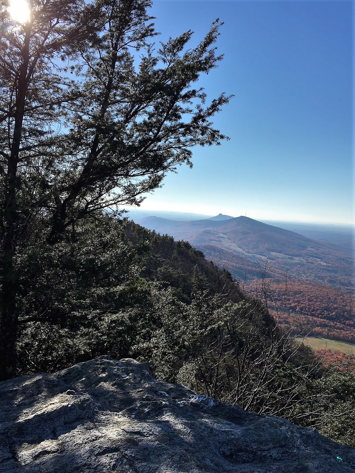
Looking north are the twin peaks of Table Rock and Hawksbill. From this angle, the peak of Table Rock looks less like a table and more like a witch's hat. Note also the color change with the higher elevation. This part of the Gorge really has not experienced fall yet!
The rugged North Carolina Wall looks imposing across the Gorge. The Gorge offers such variety in geological formations and no better example of this is the many different aspects of this photograph.
To the south is the plateau topped Shortoff Mountain and in the distant the South Mountains dissolve into a blue haze.
At the cliff, we had a Powerbar lunch and rested our dogs. The sun was hot, temperature 74 degrees, but there was a nice breeze. We considered hiking further down South Rock Jock. We could see how the trail snaked along the western rim of the Gorge. But envisioning the views we were likely to see and understanding that most the autumn color dissipated, we considered going no further. Then my Faithful Hiking Companion pointed out the steepness of the climb out....
... Agreeing with her, we cut the hike short and started the trek back to the Kistler Highway.....the hike out is a little short of one mile and it is steep....just like you see in the picture....on a hot day it was a chore.
Looking for late fall color we correctly chose the southern part of the Gorge. Trouble is we were too early even though it was the second week in November. The extreme dryness of the Gorge must explain the lack of color and the fact that many trees have not turned at all. Both hikes are short. The Pinnacle is about 3/4 out and back. The hike to Mossy, a mile out and back. We figured we put in 3.5 miles and had a real burner of a hike out of Rockjock ....enough for a Fat Bald White Guy with a sore hip for sure.


Getting to this part of the Gorge is not as hard as it may seem. Kistler Highway is a gravel forest road that runs from NC 183 near the town of Linville Falls to NC 126 west of Lake James. If you come from NC 183 it will be about a 10 mile drive down the Kistler Highway....an interesting drive but not very efficient....we took NC 126 at the Morganton Freedom High School.....travel about 15 miles crossing the Linville River...about a mile later a "Y" intersection indicates "Old NC 105" or the paved portion of the Kistler Highway...proceed up this road...it turns to gravel....the first trail head is Pinnacle....Rock Jock is about 300 yards north of the Pinchin trail head about two miles north of Pinnacle....access is great once you get there...parking for Pinnacle is good...not much parking for Rock Jock....7; trails are well marked and maintained- 9; the scenery like most Linville Gorge scenery is breathtaking-9; effort to view....on Rock Jock about right...on Pinnacle skewed to easy effort for great view....overall a solid 8+ pair of hikes.

On the way out, I paused to take this interesting photo of horses grazing in the shadow of Shortoff Mountain....


 shores of the lake and proceeds up through Huckleberry Gap. Several trails diverge from this trail and I guess the Park Rangers got tired of complaints from folks who missed the trail up to Moore's Knob. So at the intersection of the Moore's Knob Trail and the Tory's Falls trail, they erected a sign in the middle of the Tory's Falls Trail. The trail gets steep here for about a half a mile.


