Sunday, December 9, 2012

Eno River State Park - Cox Mountain Trail


       ENO RIVER STATE PARK


How many times have I taken the NC 751 exit off I-85?   Hundreds I bet and never did I realize that not five miles to the north was one of the neatest parks in the State Park System - Eno River State Park!  The Eno River is an ancient stream getting the name from the Native Americans who inhabited the river basin in pre-colonial days.  Hillsborough is upstream from the state park and it is said to be built on the site of the Eno Town named Ocaneechi. 


We decided to take the 3.75 mile Cox Mountain Trail....it was marked "strenuous"- but seriously how tough can a 300 foot elevation change trail be?


For about a third of a mile Cox Mountain Trail resembled some of the more moderate trails we hiked in the Gorge but for Orange County in Piedmont North Carolina I guess this was the best mountain they had for us 
to climb!

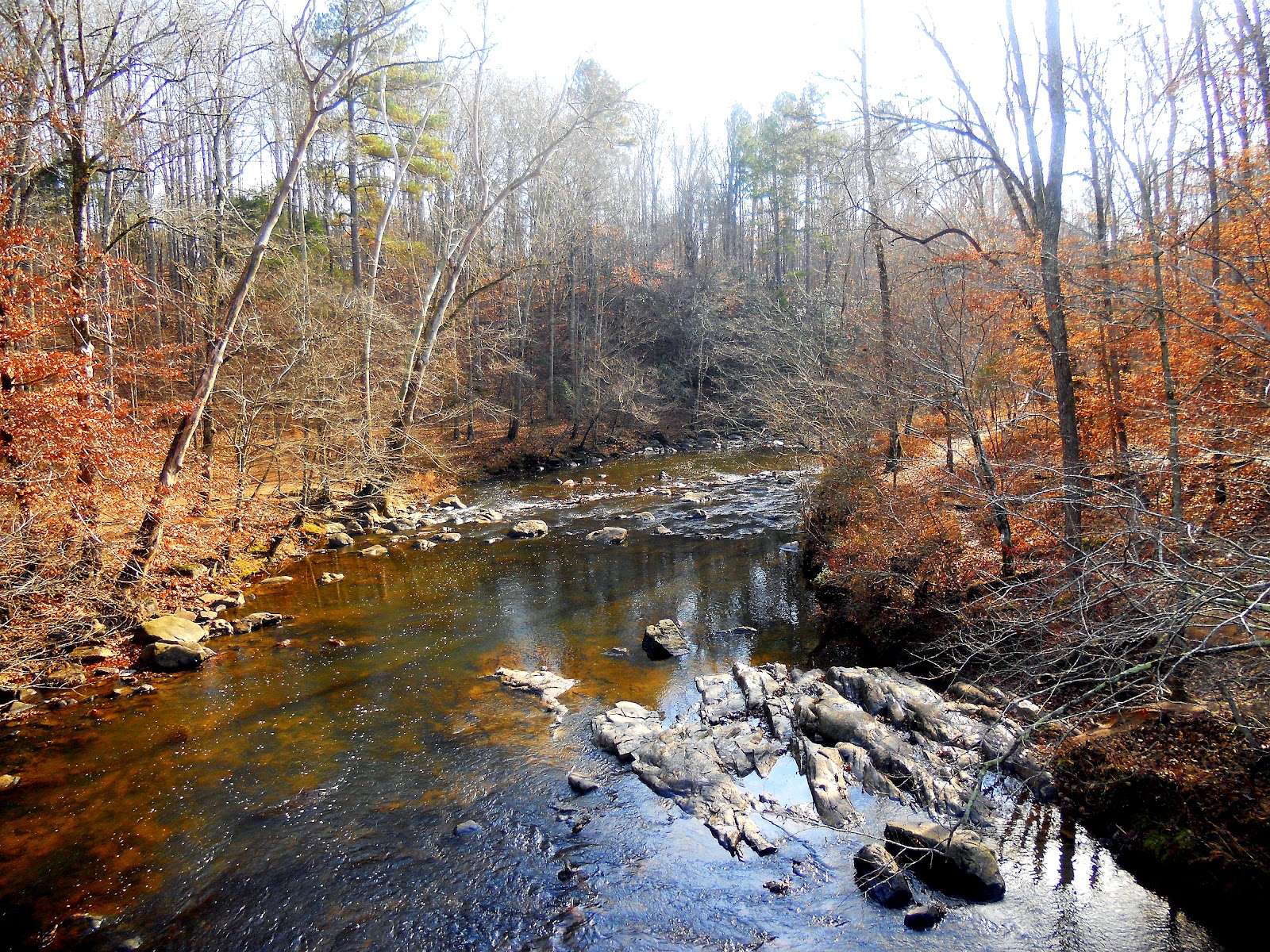
Once to the peak of Cox Mountain we were treated with a nice level ridge top trail....this would be a great fall hike!  Then we descended to the Eno Riverbanks along a large feeder stream....and as we emerged from the forest I saw the first of many incredible reflections on the mirror like surface of the quiet Eno River.


This area was the home of many early American settlers who after they ran the Eno Indians off built many homes, roads and mills along the river.


In fact the remnants of a bridge abutment still can be seen on the riverbanks and the trail along this part of the river appears to be an old stagecoach road.  Bet it was an interesting ride when the river was up.  I wonder if this was the road from Hillsborough to Durham? It reminded me a lot of the road into Basin Cove which is also used now as a hiking trail. Somehow I never considered rural Orange County as remote though.


The river was magnificent.  One stunning reflection after another separated only by small rapids.


The Cox Mountain Trail follows the old stagecoach road over the ridge and intersects with the road to Fanny Ford (what a great name?!)on the other side leading to the site of the Old Mill. This trail is a 2.0 mile loop along the banks of the river with some nice river views.   


This part of the river sports some falls of sorts...I will have to call them "Fanny Falls"...this is where we spied a most unusual sight....a girl on the trail on the other side of the river in red high heel shoes!  It would appear that she was there for a photo shoot...but had walked nearly a mile in 3 inch heels along the river trail!


The Fanny Ford is the site of a Old Mill....and students at UNC have created a nice feature to the hiking trail....just pull out your cell phone and call the number and a nice UNC Co-ed will tell you the history of the mill at Fanny Ford....but never said a word about where the name came from....dang.


Following the old mill road out from the Fanny Ford we soon found our way back to the Swingin Bridge.

Crossing the swinging bridge, we started back to the car when we spied a short half mile river trail named the Eno River Trace and being greedy for more river views we bounded down the trail...two things of note....
First, many of the trail improvements were a result of the work of Eagle Scouts....and, second,  that there was a sign indicating the high water mark of the Eno River during Hurricane Fran....easily 30 feet above the current river bank!


The Eno River Trace Trail was unique....giving a look at the replica of a river side cabin....and the unique reflections of two turtles!


We figured we hiked about 7 miles which is not bad for a Sunday afternoon adventure.   What can I say about this gem of a State Park?  The access is a 10....not five miles off   I-85 between Hillsborough and Durham.... the trails are an 8....wide, well marked and easily traversed....and the scenery is an 8....great river views.  But this trail would be brutal in hot weather....but with a 68 degree December day...we had a blast.....FBWG rates the trail a solid 8.  


Saturday, December 1, 2012

Linville Gorge- Shortoff Mountain

    SHORTOFF MOUNTAIN

                       Linville Gorge - South


From our first trip to the Linville Gorge when we climbed Table Rock Mountain, Shortoff Mountain was on my hiking bucket list....from Table Rock parking lot, it is a 11.5 mile trek through the Chimneys and over and around several smaller ridges-not an easy day hike for the FBWG....but I discovered from Wolfpit Road access....the hike is a very manageable 5.5 out and back....what can I say..."This is OUR STATE"     GO Wolfpack!       


Shortoff Mountain is the southern peak of the eastern ridge of the Linville Gorge. I was told that looking north from the summit you can see the entire Gorge. What I was not told about was the view of Lake James!  Never have I had a scenic feature dominate a hike as our view of Lake James. Every time we stopped on the trail and looked back we saw another stunning view of The Blue Lake.   


Shortoff Mountain has been the victim of several forest fires in the last decade and the devastation of those fires has changed the landscape of the mountain. Without towering oak trees, the mountain looks like one that you may hike in the Rockies....but we compared it to the scenery we observed on our hike to Mt Rogers.

To get there set your GPS to find Morganton Freedom High School....from there you easily connect with NC 126...follow this road until you pass the Lake James boat access...just ahead on the right is Wolfpit Road....the road to the "Legendary Wolfpit Weather Rock".  Go to the end of Wolfpit Road  and you will find a parking lot...the trail head looks like this. 


Be prepared for a rather steep and moderately strenuous climb...in 1.6 miles you will climb nearly a thousand feet but don't worry....every time you get tired just look over your shoulder and point out to your hiking companion another view of the Blue Lake!


From the "elbow" in the trail up Shortoff we stopped to see just how far we had hiked...down below was the Wolfpit parking lot....but off in the distance was another stunning view of...you guessed it....The Blue Lake!


Not far up the trail from the "elbow", the Wolfpit trail ends as it intersects with the Mountain to Sea Trail (MST)...and the Shortoff Cliff trail begins...we followed the cliff trail and were rewarded with a series of spectacular views! 


First we were welcomed by a flock of Falcons!
Then I spied summer daisies in somewhat of a petrified state which provided yet another interesting view of the Blue Lake. 


Not far from the trail daisies the trail begins to turn and a series of cliffs run parallel with the trail.  And views of the Blue Lake were replaced with views of the Linville Gorge!  

The further up the mountain you go the more impressive the views of the Gorge become.  This is one of those hikes where there are seemingly endless opportunities to explore side trails but you hesitate because you know that the next view will be even better!
As you approach the summit of the Shortoff the trail flattens out and for the rest of the hike you are on the plateau summit of Shortoff mountain....we resisted the temptation to explore and set off for the northern cliffs and in about a half mile we were rewarded for our efforts!
From the northern cliffs you can see the entire length of the Gorge!


The grand dame of the Gorge Table Rock Mountain peaks over the Chimneys and the FBWG could not resist posing. Note that the Chimneys form the backdrop with Table Rock is over the left shoulder and Hawksbill is over the right.

As we scampered out to the cliff pictured to the left....we encountered something we have come to expect on Linville Gorge trails.... a cairn. It was toppled over.  Not wanting to disturb the rocks still stacked, I left them and balanced the scattered rocks on top.  Again thanking the Almighty God for such a magnificent creation!  
Next summer we plan to explore the western ridge of the Gorge. On the way out we decided to take the MST to the Wolfpit trail.  It was a shorter route home but did not offer the views that we experienced on the hike in.  But we did catch one more look at the Blue Lake!

This trail is hard to rate. It was the perfect workout....great weather....great views but.....the damage of the forest fire is sad. A once magnificent forest now gone for a generation.  Remember what Yogi says:  "Only you can prevent forest fires!"  Trail access 8.....Scenery 8.....Trail 8....Overall a solid 8....

By the way I had to adorn a Shortoff Mountain Christmas Tree...Merry Christmas from the Fat Bald White Guy and his hiking companion!

Remember: "Wise Men still seek Him!"

PS:

I could not resist stopping at the Lake James Boat Access and taking a couple more shots of the Blue Lake.....hope you don't mind!

Sunday, November 25, 2012

Hagan Stone Park - Guilford County


  HAGAN STONE PARK

                Pleasant Garden North Carolina

If the path be beautiful, let us not ask where it leads   Anatole France


On a crisp November day we decided to venture to the Hagan Stone Park in southern Guilford County and hike the Chatfield 3.5 mile loop trail that encircles the park's perimeter.

The path is well maintained and wide, perfect for trail runners as it snakes around the park occasionally intersecting with numerous connecting paths.  The trail head is adjacent to the parking lot at the park entrance.  Easy access and a pleasant walk.


While the views are far from the spectacular that we have grown accustomed to seeing in the Blue Ridge Mountains, there are occasional glimpses of nature's glory. This meandering creek is one example.  The rocks remind me that the park used to be the site of a a quartz mine.....maybe thar is gold in them dar hills too!


This is the Tom O'Brien Tree....it is at this point about 1.5 miles into the hike that I learned via text alert of the firing of NC State football coach Tom O'Brien....kinda fitting don't you?


Don't know what it is about trail blazers who construct trails but there seems to always be an unusual tree along every trail we hike.


The paths are well maintained and marked every quarter mile.  On the back side of the park the path leads through what looks like an old pasture.


The sunlight piercing the through the leaves formed a unique shadow...I think I can see a cross...it was a Sunday after all!


There are many intersecting trails and two cross country running trails, one is 5K and the other is 8K...but isn't just like Americans...we think in miles when the rest of the world thinks in kilometers


We did not need this bench at the 2.5 mile marker but on a hot day this would be a good place to take a break.


Let's see a 5k trail is about 3.2 miles and an 8k trail is about 5 miles.....not so sure the ridge is much of a ridge but if we come back we will find out


Not many people were using the trail on Sunday afternoon. One lone trail runner and a few dog walkers were the only folks we saw.


The park features a nice small white church with stained glass windows on a shore of a small lake. This would be a great place for a small wedding.


Mother and Daughter Moment

The Chatfield Loop is a really nice Sunday afternoon hike....access is a 9.....trails are an 8 and the scenery is a 6....the overall hike is a 7.... Another close by treat for hikers like me who do not have time to get back into the mountains. Hagan Stone Park is south of Greensboro off NC 421.  Take a walk there soon!