SHARP TOP MOUNTAIN
"You can can never feel the real power of mountains until you start climbing their summits" - Mehmet Muran ildan


We visited Peaks of Otter on the Blue Ridge Parkway once before and climbed Flat Top Mountain. At that time we promised to return and do two things...visit the National D-Day Memorial in Bedford, Va. and climb nearby Sharp Top Mountain. The Peaks of Otter loom large in the distance as silent sentinels guarding the National D-Day Memorial in Bedford, Va. http://fbwg-hiking.blogspot.com/2013/06/flat-top-mountain-at-peaks-of-otter.html
http://fbwg-hiking.blogspot.com/2015/08/d-day-national-memorial-bedford-virginia.html
 |
| Sharp Top Mountain |
The Peaks of Otter is a popular Blue Ridge Parkway destination. It is a large park featuring a nice lake with a mountain lodge, large camping and picnic areas, visitor's center and trails to hike. The two feature mountains are Sharp Top and Flat Top. History tells us that Thomas Jefferson once sought to prove Sharp Top Mountain the tallest mountain in the original thirteen states...truth was Sharp Top at 3875' was not even the tallest mountain in the Commonwealth of Virginia. That notoriety belonging to Mt. Rogers (5725'). Heck Sharp Top wasn't even as tall as her sister mountain Flat Top (4001')
 |
| Flat Top Mountain |
Nevertheless the popularity of this misconception even led to the good folks of Virginia harvesting a granite stone from the summit of Sharp Top to be included in the construction of the Washington Monument. Most southern mountain peaks are covered with foliage. Sharp Top is unique among southern mountains in that it has an exposed rocky peak from which offers a 360 degree view of the surrounding countryside. This alluring feature is why Sharp Top has been a popular tourist destination for over a 100 years.


The hike is billed as a 1.5 mile 1250 foot trek to the summit. I have seen many different mileage calculations in various trail reports. My GPS logged 2.25 miles to the summit including a visit to nearby Buzzard's Roost. Similarly various elevation reports indicate that it is a much greater climb than 1300 feet as well. Whatever the distance and the elevation, it is a very steep and strenuous hike. My FitBit credited me for climbing 75 flights of stairs during the hike! For the faint of heart...the Park Service offers bus ride to the top...next time we make take the bus!

 The trail is easily found next to the nature center which is across the Parkway from the visitor's center. The trail is well traveled but well maintained. Expect to share the trail with many vacationers.

For about a tenth of a mile it is even smooth. After that it is a rocky trail which requires your full attention lest you turn an ankle or fall. And did I mention the steps? You encounter the first series of steps about a mile into the hike. It is but a preview of more to come once you reach the summit.

About 1.25 miles into the hike, the trail smooths out as you begin to summit the lower ridge of the mountain. At this ridge top you will find a sign giving you a choice of taking a 600 foot walk to Buzzard's Roost or a 1900 foot hike to the Sharp Top Summit. Fearing we would not visit Buzzard Roost on the way back, I chose the 600 foot path to the first real vista of the day.
 |
| Buzzard's Roost |

 From Buzzard's Roost, my astute Faithful Hiking Companion pointed out that the 1900 feet left for us to hike would be a very steep climb...ya think? Hey if they got there, we can too!


The green farmland of the rolling hills of southwest Virginia provides a nice contrast with the blue/green mountains, the powder blue sky and puffy white clouds. This is why we hike the Blue Ridge!


Leaving the Roost, we hiked back to the main trail and encountered the first of many natural cairns. This huge rock precariously perched on smaller rocks in a way that defies gravity.
"Come, let us sing for joy to the LORD; let us shout aloud to the Rock of our salvation." Psalm 95:1


Trail flowers always give us pause and on this ridge line were several nice patches of wild flowers.


"The flower offered of itself and eloquently spoke of God in languages of rainbows, perfumes and secret silence" - Phillip Pulfrey

After a laborious slog up the 1900 feet left on the trail...up steps...over rocks...huffing and puffing...wondering what the heck we were doing, we finally emerged at the Sharp Top summit.


We also met an adventurous family, Megan, Tom and Tucker. Tucker had the best hike of the day. Props to Tom. Color me impressed!
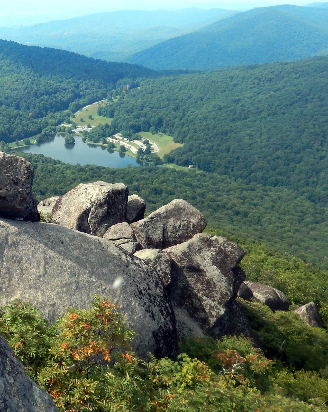
The rock formations a top Sharp Top summit were interspersed with several overlooks providing a panoramic view of the mountains and the green countryside. The distant blue lake provided a reference for us to understand the 1500 foot climb we had just made.

Nearby Flat Top Mountain gave witness to another hike we made a two years before. It too was a strenuous hike, but like today, the views were worth it.

In the green valley below is the town of Bedford and the National D-Day Memorial. Of course not every visitor to the summit felt restrained to the walled overlooks. Kyle and Latasha stood fearlessly on a rock outcropping so that the FBWG could make them famous.


 The views are incredible. Everywhere you look there is another post card vista of mountains and valleys.
The summit is also strewn with natural cairns. On a cooler day I would have scrambled on these boulders but today I must only be satisfied with photographs.

The hike up Sharp Top Mountain is a strenuous hike. But the views are amazing. The effort to view rate is skewed toward the hard hike even though the views are great.
 The primary problem with the hike is not the steepness of the trek to the summit. The reason I did not enjoy the hike was the condition of the trail. It is rock strewn making each step an effort. I could not enjoy the hike for having to watch each step lest I trip.
 So the trail rating is a 6; access is a 9...right off the Parkway with a nice parking lot and restrooms handy...the views are 9.... overall the hike is rated 8.

"On earth there is no heaven, but there are pieces of it" Jules Renard


 So the trail rating is a 6; access is a 9...right off the Parkway with a nice parking lot and restrooms handy...the views are 9.... overall the hike is rated 8.
"On earth there is no heaven, but there are pieces of it" Jules Renard


