CABE LANDS

Finding the trail head is pretty easy.

From the west get off at the NC 751 exit just past Hillsborough and follow the signs to the Historic Bennett Place. Within sight of the turn off to the Bennett Place you will see some stoplights at the intersection of NC 70 and Sparger Road. Turn left on Sparger Road and just across the 1-85 bridge take a left on Howe St. At the end of Howe St. next to a trailer park is the parking lot for Cabe Lands. I noted the signs about recent vehicle vandalism. For once I was glad I was a CCW permit holder....just sayin...

 According to Eno River Trails.com, Cabe Lands refers to the lands occupied by Barnaby Cabe in the years prior to the Revolutionary War. The Cabes were originally Tories, loyal to the King but fortunes of war made them sufficiently loyal to the Patriot victors that they purchased land on the Eno from the State of North Carolina. On this land, his son, John constructed a grist mill. Married three times, John Cabe sired nine daughters! Needless to say most of the settlers are in the family lineage of John Cabe.

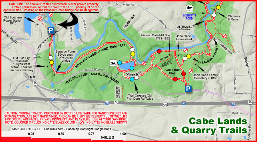
From the trail head leads a wide graveled trail. About 200 yards from the trail head, a trail cuts to the left. This trail leads to the Quarry Trail about a half mile away.
The Quarry Trail is a .4 of a mile connector to the loop trail around the quarry lake. Total distance is 1.2 miles of very pleasant hiking.
 Late autumn still provided some colorful displays of foliage. The stroll around the lake provided several different vistas of one of the nicest quarry lakes I have ever seen.

 Of course we met some nice people on the trail. Lou Ann and Derward are from Durham and recently hiked out west. Their stories made the FBWG jealous, but then again there are really many trails in the Old North State I have yet to hike so I guess I am gonna put a trip to the west on hold till I finish up around here. Nevertheless I promised to make them famous by putting their picture in this blog.
On the east side of the quarry lake, the loop trail picks up the Mountain to Sea Trail. A short scramble off the trail and you can get the first glimpse of the day of the Eno River as it meanders over the rocks. Tracing our path back up the connector trail, we took a left turn at the Quarry Loop sign and proceeded down to the river banks.

At the river, I explored a trail up the river to the west and climbed on a rock promontory and took a picture of the remnants of the old dam just downstream from the quarry we just visited.

 Backtracking to the Cabe Land loop trail we continued on a pleasant walk along the river. The rocks allowed the FBWG to climb to the middle of the river and take a picture to the west upstream and turn around and take a shot to the east downstream.
The Eno has a quiet elegance to its flow. It is a very old river and there seems to be no reason for the water to hurry downstream.

 Not far from this blaze orange tree were two newly constructed footbridges which it turns out crossed the mill streams from the old mill.
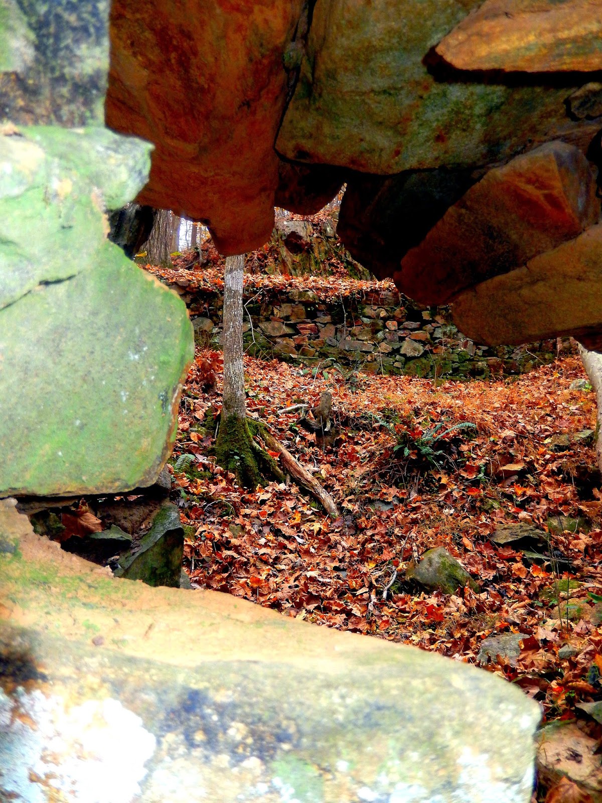
I imagine in the summer time, it may be hard to locate the old mill. But the stone foundations are about 75 yards from the foot bridge.


Leaving the mill we veered off the Cabe Land loop and continued down the riverside trail. We caught a couple more nice views of the Eno River. The old river is always good for nice reflections.

The riverside trail turns away from the river and heads up the bluff toward the graveyard and the home place site but not before the river provided one last parting shot.

Leaving the river we assumed we were on the trail to the graveyard but there were so many leaves we must have missed the trail. Turns out we were on the Laurel Bluff Trail which soon led us back to the Cabe Land Loop trail above the home site.
 We elected to continue back to the car where we discovered that the graveyard trail just like the map shows runs parallel to the Cabe Land Loop Trail at the trail head. Maybe next time we come we will reverse our course and see the graveyard first. One of the tidbits of history which Eno Trails.com pointed out was that John Cabe's great grand daughter married Lorenzo Bennett. His family had a farm on the Hillborough Road about seven miles from Durham. Lorenzo was a Confederate soldier who died during the Civil War from some ailment.
The significance to all this is that the Bennett farmhouse is where the Civil War ended.

It is the place where General Joseph Johnston surrendered to General William Tecumseh Sherman.

The trail is a moderate trail with a number of neat things to see. The Eno River at one time bustled with businesses.

There were mills and quarries together with homesteads and interrelated families. Only remnants of which bear witness to days long past. Trail access is an 8....despite the fact it is easy to find, the FBWG don't like to have to worry about vandals or pack heat to go on a hike. The trails are well marked and maintained-9; The scenery, though unspectacular is interesting and varied-8; The effort to view ratio is low but it is the Eno and the trails are not strenuous and the views are what you expect.