Sunday, November 14, 2021

MAYO RIVER STATE PARK - FALL CREEK FALLS


FALL CREEK FALLS

Mayo River State Park is scattered along the Mayo River in Rockingham County, North Carolina near the border with Virginia.   We hiked a small section of the park originating the Deshazo Mill Road access.  The trek is only about 3.0 miles but contains some of the most scenic creek and river scenery imaginable.
Fall Creek Falls is the feature attraction on the hike and is located no more than a quarter mile from the trailhead parking lot.  If you are coming to see the falls, you can do this without breaking a sweat.
The falls are about twenty feet tall and are formed as water from Fall Creek encounters a large granite rock. From the water marks on the rock face, these falls have a much wider cascade during raining seasons and forms a nice pool at the base of the falls. 


The trail is a well marked path along the banks of Fall Creek as it meanders to the Mayo River. I called it "Ginger Creek" as the leaves of the late fall cast a ginger sheen along the trail.


The trail meanders along the banks of Fall Creek for about a three quarters of a mile. There we emerged from the ginger forest as the trail intersects with what I believe to be the Mayo River Trail.  We took a right at the intersection and proceeded upstream along the banks of the Mayo River.  The river scenery was stunning!

The Mayo River is named for Major William Mayo who was an assistant to Colonel William Byrd who first surveyed the boundary between North Carolina and Virginia. His journal contains some of the earliest accounts of the settlements in this area. The river forms in Patrick County, Virginia and contains two forks which eventually join above Stoneville North Carolina in Rockingham County.  It eventually merges with the Dan River near Mayodan. 


As we proceeded north on the trail following the river upstream, we encountered a fork in the river. The main stream followed along the trail to the north west, but to the west was fork which was shrouded with late fall color.  I suspect these are the two forks of the Mayo.


Not far from the forks is a small rapid which is formed as the river flows over a large granite rock formation that spans with the width of the north fork of the Mayo.


Climbing out on the rocks, I got some of the best pictures of the day, both upstream and downstream.


Just north of the rapid is a tree and on the tree is a notice that the trail is now crossing into the state of Virgina.  The markings changed from a blue "hiking" emblem to a painted white mark.  The trail proceeds for another quarter mile until we were stopped by a "No Trespassing" sign. 


Backtracking up the trail, the views just kept coming.  This part of the Mayo in the late fall evening seems to change as the sun began to set to the west.
Always amazed at the mirror like reflection that still water provides nature's scenery.  Fall Creek on the hike out provide one of those special scenes.  
Reflections on the slow moving Mayo River where also easy to find, especially as the sun emerged from the clouds.

While this trail is relatively short...about 3 miles total...it is jam packed with scenery.  A ginger forest empties into ancient river, what more can you ask for in a Sunday afternoon hike? Located near the Virginia line, the access is off Smith Road on NC 220.  Deshazo Mill Road is a remote partially paved road and you will need your GPS for the first trip there. Small gravel parking lot marks the trailhead.  Access is rated 8.
The scenery is a solid 9.  Anytime you have a waterfall, a creek through the forest and an ancient river, you have plenty to see.

The trail is a narrow forest, creek and river bank trail, but is well marked and well worn. We encountered two other groups on the trail on a Sunday afternoon, so the trail is well used.  Rate that a 9.

This is a great family trail. It is 45 minutes north of Greensboro.  It is a very easy, scenic trail.  A great place for a riverside picnic, and I imagine a nice wading pool beneath the falls on a hot summer day.  This is a solid 9 hike.  Sure glad we visited!


Saturday, October 23, 2021

ROAN HIGHLANDS

 AN AUTUMN HIKE TO GRASSY BALD

Round Bald and Roan Mountain 

The Roan Highlands on the border of the North Carolina and Tennessee have always been a favorite place for the Fat Bald White Guy and his Faithful Hiking Companion to visit.  This was our third trip...this time in Autumn. 
The Roan Balds are a series of treeless summits extending northeastward from the base of Roan Mountain at Carver's Gap into North Carolina.  The grassy high mountain tops are some of the highest peaks in the Appalachian Mountains. The hike from Carver's Gap to Grassy Bald provides a continuous panoramic view unequaled in any trail I have hiked.
The Appalachian Trail crosses these balds and provides a well marked and well maintained path to the summits.  The picture above is from the descent of Round Bald to Carver's Gap looking southwest into Tennessee.


The Carver's Gap parking lot is a very social place.  In the fall and in June, the Balds receive many visitors to enjoy the colors that nature displays.  The hike to Round Bald is one that almost anyone can make easily. Going further on the trail to Jane Bald and Grassy Bald are a bit more difficult but are worth the effort.


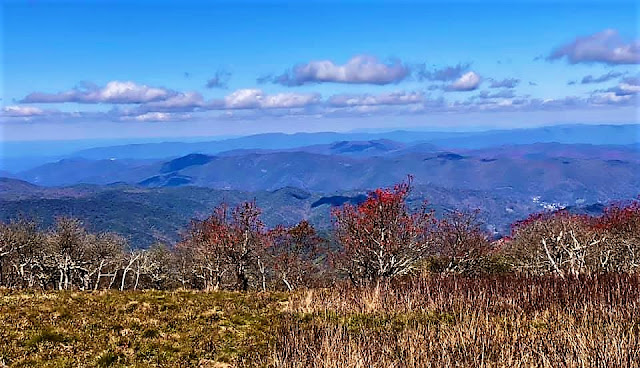
The day we visited, the leaves were at peak color about 5000 feet and thus provided a ginger ring beneath the summit of the balds but leaves at lower elevations had not yet began to turn.
From the western slopes of the balds, views of both Tennessee and North Carolina can be enjoyed the view above is looking into North Carolina, with Elk Knob in the distance.  The picture below is looking westward into Tennessee over the hamlet of Roan Mountain.
The summit of Round Bald is only about a mile from the Carver Gap trailhead...to get to Jane Bald you must commit to another mile but the views are worth the effort.  
The summit is well marked with views southwest into Tennessee and  northwestwardly into North Carolina. There you can see Grandfather Mountain in silhouette above the distant Roan Balds.  Don't forsake the nice rock trail bench to rest your dogs!

From the trail bench a view back up the trail will remind you why you are so out of breath. Though the elevation from Carver's Gap to Jane Bald is but 500 feet, you have to factor in a climb to Round Bald followed by a descent into Engine Gap, then a climb up to Jane Bald.
Once a top Jane Bald, the trek up to Grassy Bald does not look either steep nor far. In truth it is a mile climb to the top of the 6183 foot peak.  But in truth, you cannot experience the majesty of the Roan Highlands unless you summit Grassy Bald.
Grassy Bald provides a mile wide grassy summit from which incredible vistas emerge every time you turn your head to look at a distant peak.  From one vantage point you can see three of the tallest mountains in the Applachians.  To the northeast is 5945' Grandfather Mountain and the distinctive Sugar Top condominiums.
To the south is the 6245'  Roan Mountain.
But to the southeast is the Grande Dame of the Appalachians, the 6683' Mt. Mitchell and the Black Mountain range.
Between the Grandfather and Mt. Mitchell vistas are the distinctive peaks of the Linville Gorge.
When asked of the perfect hike, I immediately respond..."Carver Gap to Grassy Bald"!  There is no hike that provides this many stunning views of the majesty of the Appalachian Mountains.  Three miles up and three miles back including five ascents!  Your legs will burn, your chest will thump but your soul will be renewed!
On the southeastern slope of Grassy Bald is a rock formation that provides the best trail bench imaginable.  From that perch, you can look at the majesty of Mt Mitchell and feel very small.

"And if these mountains had eyes, they would wake to find two strangers in their fences, standing in admiration...These mountains, which have seen untold sunrises, long to thunder praise, but stand reverent, silent so that man's weak praises should be given God's attention." (Donald Miller)
Make this a bucket list hike.  Once you go, you will find that these mountains have their own souls which they will open to you. They will speak to you in ways unimaginable. Standing among them, you be still and know that there is a God who weaved a masterpiece of this world, a glorious tapestry of majesty and color.

Nuff said....Amen!
"We are in the mountains now and they are in us, kindling enthusiasm, making ever nerve quiver, filling every pore and cell of us"- John Muir


"Thousands of tired, nerve-shaken, over civilized people are beginning to find out that going to the mountains is going home; that wildness is a necessity."- John Muir
"Climb the mountains and get their good tidings. Nature's peace will flow into you as sunshine flows into the trees. The winds will blow their own freshness into you, and the storms, their energy will drop away from you like the leaves of Autumn"- John Muir

"How glorious the sun gives greetings to the mountains in the morning" - John Muir


"Another glorious day, the air as delicious to the lungs as nectar to the tongue" - John Muir

"Society speaks and all men listen, mountains speak and wise men listen" - John Muir
"One touch of nature makes the whole world kin" - John Muir 

"One day's exposure to the mountains is better than a cartload of books" - John Muir